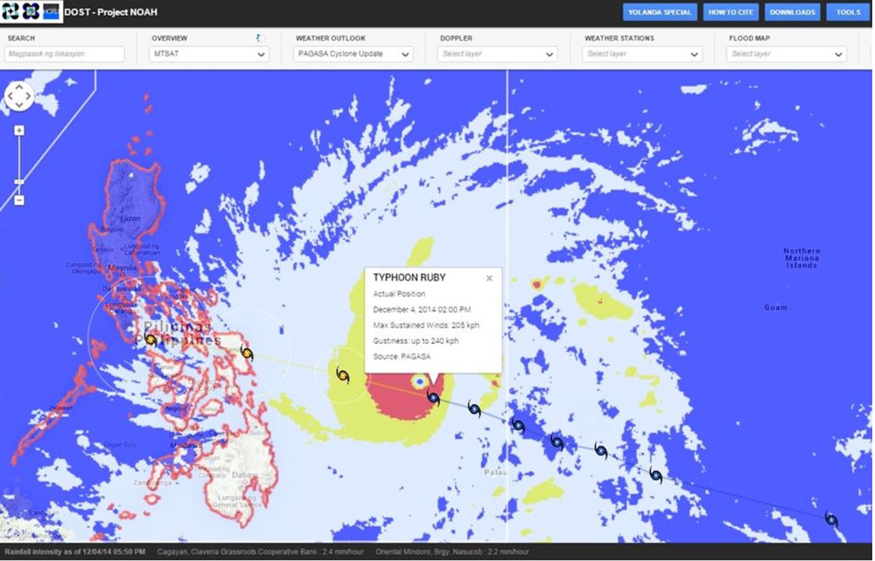
DOST-Project NOAH is now out with a storm surge simulation model indicating which areas in Samar and Leyte are likely to be inundated as a result of Typhoon Ruby hitting Region 8.
The model was presented by NOAH Executive Director Mahar Lagmay in a press conference at the PAGASA Operation Center this morning (Thursday). The model initially covers the provinces of Samar and Leyte since they fall right along the path of typhoon.
Lagmay said the model may change from time to time, depending on the forecasted behavior of the typhoon.
“We will be updating the height of the surges every six hours, and we will put it on Project NOAH website because this is only as good as the typhoon forecast. This includes the maps of the storm surge inundation,” he said.
As of 10pm Wednesday, the storm surge simulation model covers 21 municipalities in Samar, Leyte and Cebu. The scenario reflected in the modeled on a three- to four-meter high storm surge.
Lagmay said that based on 10am PAGASA forecast track, the concentration of the storm surge, which may rise three to four meters, may be in Northern Leyte, Samar, Basey and Tacloban. During Yolanda, the storm surge in the area went as high as five to six meters.
He said PAGASA and Project NOAH have devised a system of storm surge advisories based on the peak height of incoming big waves, namely:
· SSA 1 – 2 meters
· SSA 2 – 3 meters
· SSA 3 – 4 meters
· SSA 4 -5 meters and higher
Meanwhile, PAGASA stressed that even if the storm is expected to make landfall somewhere in Eastern Samar, it may affect areas even far from the point of landfall considering it has a diameter of around 600 kilometers.
Project NOAH has devoted a special webpage http://blog.noah.dost.gov.ph/typhoon-ruby-hagupit/ for updates on typhoon Ruby.
Most reliable
Meanwhile, Science Secretary Mario Montejo called on the public yesterday on keep monitoring developments on typhoon “Ruby” through weather bureau PAGASA and Project NOAH, saying the information they are providing are now the most reliable with the typhoon’s entry into the Philippine Area of Responsibility.
He said this is because the typhoon has become nearer PAGASA’s sensors and observatory equipment.
PAGASA Deputy Administrator Dr. Flaviana Hilario explained “it is important to note that once a storm or typhoon enters the Philippine Area of Responsibility (PAR), the information of PAGASA becomes more reliable than those provided by its foreign counterparts because it is able to acquire more observational data from different field stations in the country.”
“In fact, foreign warnings agencies make use of PAGASA information once the weather disturbance gets within the range (400 kilometer radius) of our meteorological equipment such as radars and automatic weather station,” she added
Montejo has been taking the lead in typhoon monitoring at the PAGASA Flood Forecasting and Operations Center since Wednesday, even before Ruby entered the PAR.
At of 10am today (Thursday), PAGASA located the eye of the typhoon at 860 kilometers East of Surigao City (10.1oN, 133.3oE), moving west northwest at 20 kilometers per hour with maximum sustained winds of 195 kilometers per hour near the center and gustiness of up to 230 kilometers.
“As we had predicted, the typhoon further intensified as it approaches the landmass at a slower pace. This means, we have to prepare as we are faced with a typhoon that brings destructive winds and heavy to intense rains within the typhoon’s 300-kilometer radius of uncertainty,” Montejo said.
“It would help a lot if the people, including Local Government Units, take the information we are providing seriously as they prepare. Let us take all the necessary precautions without having to panic,” he added.
Montejo also appealed for an end to sending prank messages on typhoons through SMS or social media. “If you find it fun, you should realize that the lives and properties of people to be affected by the typhoon are at stake here.”

